Hiking Aagottind, Norway
The courage to retreat: embrace the adventure, but “don't be ashamed to turn around"
May 12, 2023
5 min read
We were challenged to follow in the footsteps of the Norwegian TV show "71° nord". Excited, we immediately said "yes"to this opportunity. Aagottind is a rarely visited mountain in Eikesdalen, Norway. The valley is the neighboring valley to the well-known Romsdalen with its Trollwall.
Text & images by Åse Johanne og Rune Millerjord
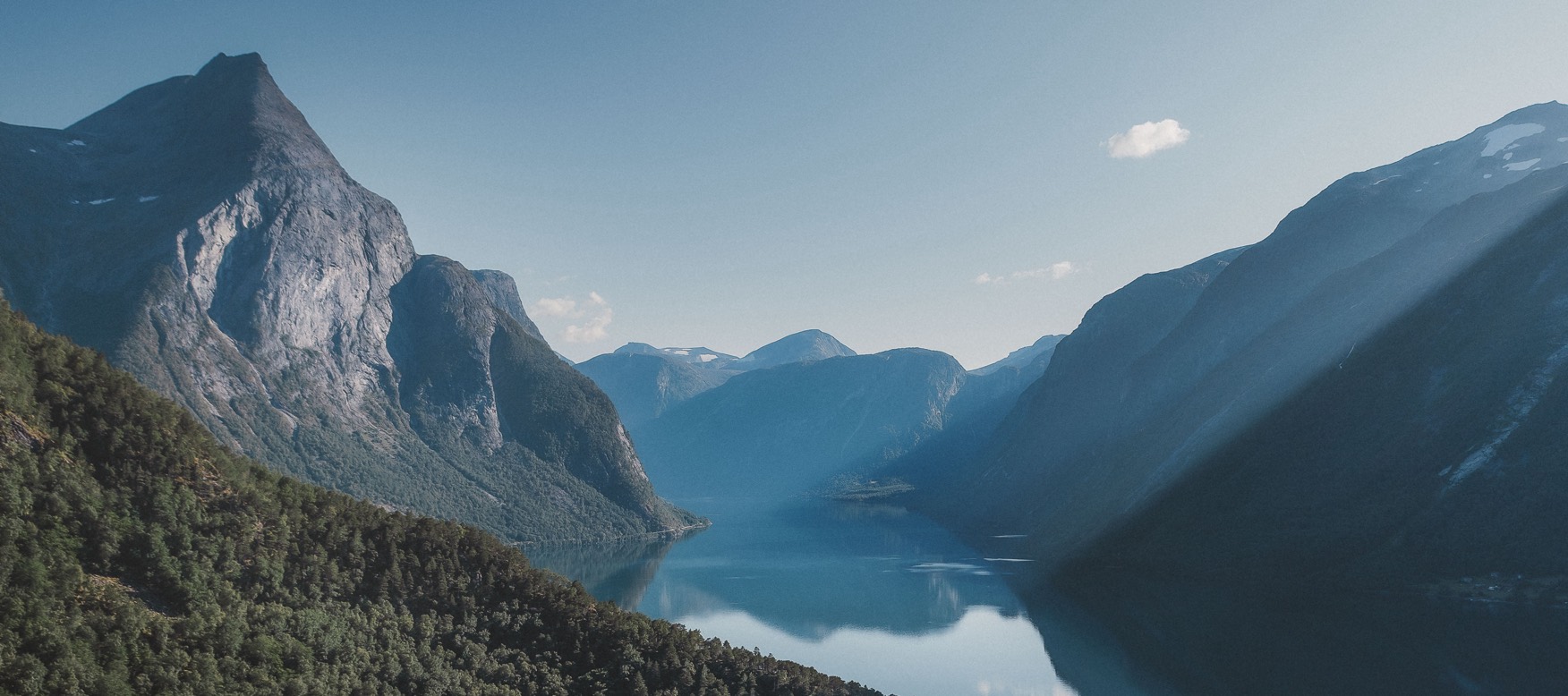
Eikesdalen is characterised by the turquoise colored Eikesdalsvatnet that winds through the valley. Around the lake, several peaks tower at 1,700–1,800 meters and the nature here is wild, beautiful, and enticing. In the area, you can also find Gjuratinden, Goksøyra, Mardalsfossen, and Aurstaupet, which are perhaps better-known mountains and attractions in the area.
About the hike
- Distance: 2,5 km each direction depending on the route
- Duration: approx 12 hours
- Difficulty: Expert/challenging
- Total elevation gain: 1,526 meters
- Start/end: Small parkering area at “Fløtaelva” (30 meters above sea level)
Our love for Eikesdalen and the fantastic nature in this area has resulted in several trips in the region. There are many “must visit'' places in the valley, and you will find hikes and adventures for every skill level. The most famous locations are Mardalsfossen, Aurstaupet, and Aursjøvegen which are also placed in the vicinity of the lake.
Traditionally, Aagottind or "Ogottind" is a paraphrase of the Norwegian word "u-gått-tind," which means "an unclimbed peak." Despite this, the peak has been climbed before. However, compared to other peaks in the area, it is very sparsely visited, due to its challenging terrain.

A "good" plan
Good planning is essential for a safe and enjoyable hiking experience, including considerations for weather, necessary equipment, food, drink, hike length, steepness, and potential risks.
The information we found about Aagottind was somewhat limited. Hike descriptions and recommendations were variable. We did not know which exact route the TV show "71° nord" had chosen up the mountain, so we based our plan on a description we found on the web. We also tried to gather more information from locals who knew the area and received a friendly advice to reconsider our choice of peak.
We usually bring a lot of photo/video equipment, which adds extra weight. The plan was to complete the hike on a day with good weather and during daylight hours. We brought ropes, harnesses, and safety equipment because it was unclear what we would encounter in terms of steepness and safe route choices. Based on the information we had gathered, we knew that probable challenges on the hike would be an indistinct path, loose rock, steepness, and added weight due to our photo and safety equipment.
The mountain was described online as a hike that could be safely done without ropes, but studying the map and looking at pictures from others who had been in the area made it an easy decision to bring climbing gear.
Before the hike, we agreed to prioritize safety. Our choice of route had to be feasible without exposing ourselves to unnecessary risks.
Pack list:
- Sturdy approach shoes with a good grip
- A change of clothes and windproof clothing
- Backpack (25-45L)
- Water
- Climbing equipment for safety: We had a lightweight half-rope (certified as single, double and twin rope), camalots, set of stoppers, nuts, some carabiners and helmets.
- Map/Compass or fully charged phone/power bank
- First aid kit

From Sunndalsøra to Eikesdalen
When exploring the Eikesdal area, both Sunndalsøra, Åndalsnes or cabins/ tents/camping in Eikesdalen itself can be good starting points for longer stays in the area. After a good night's sleep in Sunndalsøra and with a weather forecast indicating good weather for a couple of days, we set out before dawn.
The starting point for the hike was set at “Fløten”, where the “Fløta” River flows into Eikesdalsvatnet. There was no clearly marked trail, but for the first 200-250m, we could follow a tractor road a bit up into the terrain. Further up, we followed various animal tracks towards the ridge of the mountain and the “Fagerbotnen” valley. Here, we kept to the left of the ridge, at a safe distance from the cliff on the right side.
Thick undergrowth and an unclear path that occasionally pointed in all directions, or simply disappeared altogether, made choosing the right path challenging in the first part of the hike. From time to time, rockfall could be heard from the other side of Fagerbotnen, without us seeing any movement of the stones.

At about 600-700 meters altitude, we encountered a "wall" that we did not immediately find a way around. After a little searching, we found the path and an opening that made it possible to overcome this crux on the trail. From here, the trail went up, over a very steep and moss-covered slope. Much of the rock mass in the area was loose, and there were few opportunities to secure good anchor with our equipment.
At 800 meters, we eventually had to acknowledge that weight, steepness, time, and a lack of opportunity to climb up in a sufficiently safe manner, turning back was the right decision.
Aagottind proved to be a challenging and sometimes dangerous mountain, with a high risk of rockfalls. This is not a hike for everyone and requires good experience and confidence in the mountains, making your own assessments, and knowing your limitations.
As soon as we crossed the treeline, we enjoyed the view of Eikesdalen and a multitude of mighty peaks around Eikesdalsvatnet.

”Don’t be ashamed to turn around”
As adventure photographers, we're always chasing that perfect shot, that awe-inspiring moment that takes our breath away. It's what drives us forward, propelling us to push ourselves to our limits in pursuit of our goals. But sometimes, the most important decision we can make is to “turn around”.
Many people see turning back as a failure, a lack of willpower or determination. But the truth is, it's a sign of responsibility and respect for the environment around us. When we're out in the wild, we're at the mercy of nature's forces. We need to be mindful of our own limitations and take precautions to stay safe.

Knowing when to turn back is an essential part of any successful hike or adventure. It requires a certain level of self-awareness, an understanding of our own abilities and capacities.
As the old mountain safety rule says, "Don´t be ashamed to turn around." It's a reminder that we're not invincible, and that we need to respect the power of nature.

Tips for good decision making when you are exploring the outdoors:
- Planning phase: Think ahead about the reasons that will lead you to turn back during the hike. This decision can be challenging when you are in the middle of the situation.
- Have knowledge about the weather: Evaluate the weather in the area where you are planning the hike. Check several times and make this one of the things you do both early and late before departure.
- Assess risk: Consider what situations may arise, what is the likelihood of an event, and what are the consequences? Is the steepness, weather, distance, or altitude a challenge for me? Do I need safety equipment? If you do not feel safe in the terrain you will be travelling, using a guide is a good solution.
- The Mountain Code: In Norway the “Mountain Code” is part of the culture when planning an adventure in the outdoors. The mountain code consists of 9 simple rules, meant as a guide to help people plan for a safe experience in nature.
About us


We're a couple of adventure photographers with a love for the outdoors. Our passion for capturing nature's beauty through photography and videography has sparked a journey as photographers and content creators with a focus on the importance of the human and nature connection. Our passions include climbing, hiking, kayaking and skiing.
Explore Outdoor gear

Men's HH Tech T-shirt 2.0

Men's Verglas Infinity Shell Jacket 2.0

Men's HH Tech Crew Long Sleeve 2.0

HH Sou’wester Hat

Men's HH Tech Half-Zip 2.0

Men's Holmen 5 Pocket Trousers 2.0

Men's HH Logo T-shirt 3.0

Men's Glacier Down Jacket

Women's Belmond Sandals
